

.png)
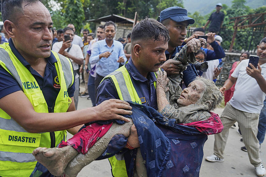
The devastating floods that have swept through the Nepal–Tibet border region are first and foremost a human tragedy. Hundreds of people have died or remain missing.
But as scientists begin to reconstruct what happened, the event also exposes something fundamental about the way we understand natural hazards in high mountain regions. Mountains and rivers do not reset after an extreme event. A landslide changes a slope. A flood rearranges a river. A retreating glacier exposes sediment and unstable ground. Each disturbance changes the conditions in which the next one occurs. In the Himalayas, those connections can turn individual hazards into destructive hazard cascades.
Early satellite and seismic evidence indicates that this disaster began high in the mountains with the collapse of part of a slope and steep glacier in Tibet. A huge mass of ice and rock travelled rapidly into the valley below, mobilising water, sediment and debris that then spread through the river system and into Nepal. The precise mechanics of the event will take time to establish. But describing it simply as a flood captures only the final stage of a much longer process.
I am involved in a UK-Indian academic project that starts from a simple proposition: hazard risk in the Himalayas is not static.
Climate change is changing how hazards interactFor instance, retreating glaciers can leave behind unstable slopes and large stores of loose sediment. Some have been described as “sediment bombs” because huge quantities of material can remain in a valley until released by another landslide, severe rainfall or a flood. The first hazard therefore changes the landscape in which the next one happens.
It would be wrong to conclude from a glacier collapse alone that climate change caused this particular disaster. Individual events require careful attribution, and steep Himalayan landscapes have always experienced landslides, avalanches and floods. But climate warming is changing the background conditions in which these processes operate: glaciers are retreating, the slopes they inadvertently support are being destabilised, new lakes are forming and large volumes of loose sediment are being exposed. Warmer air can also hold more moisture, increasing the potential for intense precipitation.
More importantly, these changes are making hazards even more connected. Changes in glaciers can influence slope stability. Slope failures can obliterate glaciers in seconds and alter entire river drainage patterns. Altered rivers can mobilise sediment. Sediment can amplify subsequent flooding.
Additionally, mountain landscapes retain a physical record of what has happened before. A landslide can load a river system with debris that takes years or decades to move downstream, altering channels and changing how later floods behave.
Heavy rain falling on a relatively stable catchment with a clear river channel is one thing. The same rainfall after a major landslide has deposited millions of tonnes of sediment and narrowed that channel is another. The hazard and trigger event may be similar. The landscape it encounters is not.
In the latest Nepal disaster, sediment will have been redistributed through the catchment. Channels will have changed, and some slopes may have been destabilised. Embankments that once guided water and sediment have been damaged or destroyed entirely.
Communities can carry these effects forward too. The same river corridor experienced serious flooding in 2025, when lives were lost, a Nepal–China friendship bridge was destroyed and transport and trade were disrupted. Some communities affected this week were still living with the consequences of a previous disaster.
Disaster planning needs to factor in a changed landscapeEarly warning has to keep up and this disaster is a further wake up call to address fundamental challenges around disaster-risk management. Early-warning systems are often built around known hazards and known thresholds: a particular river level, rainfall intensity or unstable slope. But major events can change the geography of the risk itself. After a landslide or debris flow, a previously minor tributary may contain huge quantities of mobile sediment, while a river that previously carried monsoon floods safely may have become shallower or narrower. Evacuation routes can disappear.
A hazard map produced before such an event may therefore provide an increasingly poor representation of what happens afterwards. One of the aims of our project is to develop ways to track those changes and feed them into risk assessments and new smart early-warning systems.
Cascades thinking means asking how one disaster changes the conditions for the next. The floods in Nepal will leave behind altered river channels, unstable slopes and damaged infrastructure. The next heavy rainfall – or collapsing glacier – will encounter that changed landscape.
Daniel Parsons receives funding from the Natural Environment Research Council that are funding work in this region.


 (1).jpg)
 (1).jpg)
 (1).jpg)
 (1).jpg)